Looking for a more challenging way to hike Snow Mountain? The Zhijiayang trail may be just what you are looking for. This was the path to Snow Mountain before the East Peak Trail was built. It can be done in 2 to 3 days covering roughly 30km. This trail is more challenging due to sections being overgrown and undermarked, and also because of the steep, precipitous south ascent of Snow Mountain. Below you can find details from my recent 3-day hike following this path with a photo gallery and hike data:
Zhijiayang Mt. to Wuling Farm 3 Day Hike
Day 1:
The hike begins in the small village of Huanshan. The trail begins about 10 minutes drive from the village, just across a short suspension bridge. Here you can drop your permits into the box and set out along the river. For the first hour, you walk relatively flat ground along the river and through some cabbage farms and persimmon groves and crossing a few small bridges. You will arrive a green bridge crossing a stream and here is a good place to fill your water (also a good place to camp the night before your hike if desired). Shortly after, you will arrive at the trailhead for Zhijiayang Mt. From here, the trail climbs steeply up and doesn’t relent until you reach the summit at 3000+ meters. The ascent is only about 5km (the peak is at the 8km marker), but it is a grueling climb(1,800m elevation gain). This section of the trail is steep, but it is well maintained and has good footing. There are a few small rope sections but nothing too intense. The trail is also well flagged by hiking groups and there are trail signs pointing the way. There were also quite a few people on this section, doing day hikes to Zhijiayang, so you won’t be alone here.
The first major landmark is located around the 6km marker at Sai Liang Jiou campsite(~2600m). It’s not much of campsite really, more a small clearing capable of holding 2-3 tents maybe. From here, the forest begins to thin and you are rewarded with some views of the nearby mountains. You will continue ascending another kilometer before reaching the ridgeline near 3000m and then arriving at the Piaodan pond and hut. There is a small decrepit shelter and if you are lucky, a small pond. We were not lucky and the pond was dry which created a water problem for us. So be aware that you may not be able to get water here. From Piaodan, it’s about a 30 to 40 minute slog up to the unofficial peak at 3,289m. Here you will find the peak sign for photographs and stunning views of the surrounding mountains. However, the actual peak is about 20 minutes further up located at 3,345m.
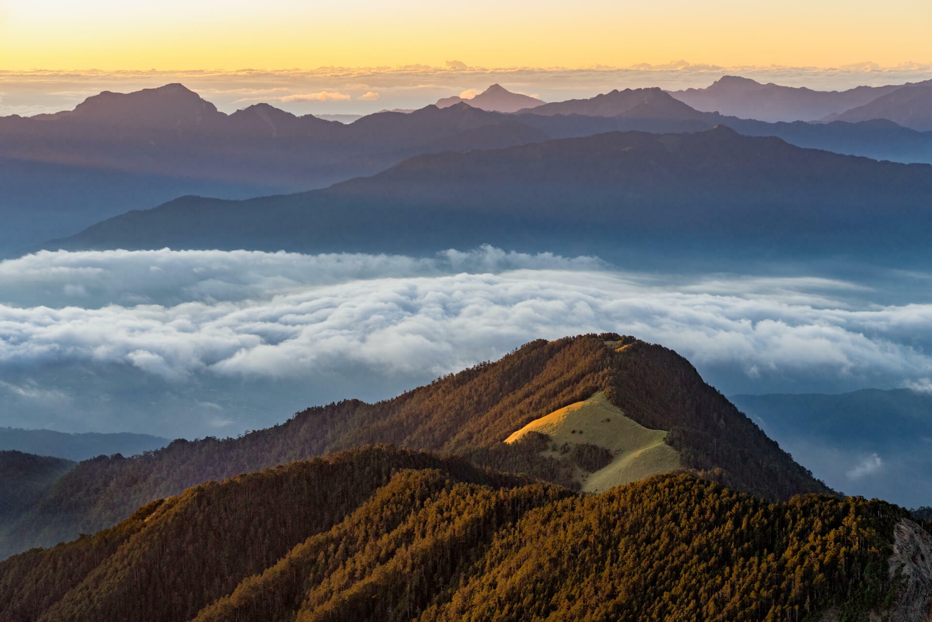
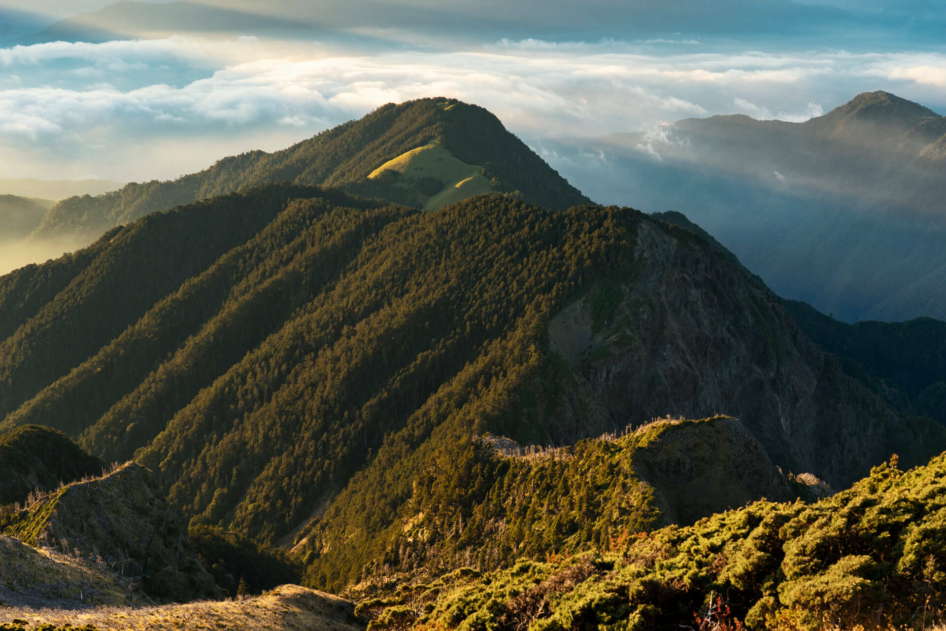
From the peak, the trail immediately becomes overgrown with thin bamboo shoots. You will have to force your way through, keeping your eyes on the ground to stay on the footpath. After about 15 minutes of this, you will come out into a clearing along a ridgeline where you can trace your path for the next hour or so. The path follows the ridge with many sections being very overgrown and hard to pass. Just keep your on the ground in these sections and you will see the footpath. Be very careful though, as the several sections are very close to the edge and a fall would most likely be the end for you. There are a few signs and markers on this section and an occasional flag so keep your eyes peeled. At the end of this section there is a tough 20 minute ascent up the ridge through an overgrown section of trail. After forcing your way through this mess, you will enter into the forest. Here the trail is much better and easier to follow, though trail flags are sparse.
There is one tricky part of the trail where some downed trees have blocked the path and there are no flags. If you look closely, you will see some foot holds carved into these trees. The trail will continue just above and beyond this point. Beyond here, the trail is not too difficult to follow and there are trail flags and markers leading the way. Just beyond the 10.8km marker, you will arrive at the campsite for the day. The original Snow Mt. cabin used to be located here, but now it’s just a clearing capable of holding about 10 tents. The site is surrounded by forests and is a wonderful place to spend the night.. The site is located at about 3,250m at the base of Snow Mountain South Peak. At this elevation, the night is very cold, so be prepared . There is a water source about 200m downhill from the campsite. The trail is not well marked and is very overgrown, but it is there. When I was there, there were only few small pools of water, but it was enough.
Day:2
We began day 2 by summiting the south peak. From the campsite, the trail begins just behind the campground sign. There is a large tree which has fallen and blocked the trail but if you look closely, you will see an orange marker and the trial just above and beyond. This path is a little tricky to follow, but there are flags along the way. The ascent takes about 30-40 minutes and at the top you will have a great view of the Snow Mountain’s south ascent (which you will climb soon). There is no marker at the top, just a small rock with name painted on it. After enjoying the views for a few minutes, we headed back down to the camp which takes about 20-30 minutes. After breakfast, we headed out for Snow Mountain. We stopped by the water source again and refilled then backtracked up to the trail.
*The trail here is very overgrown and there is only one white flag marking the split. To the right is the water source and up to the left is the trail. Look carefully.*
The trail continues on for a bit in the forest before dumping you out into a large rock fall area which you will need to ascend. You will follow this rockfall for the first half of the ascent. On the way up, there are 2 ropes to the left with trail flags. DON”T follow them, as this path is no longer passable. Continue up the rocks and you will see more flags and rock cairns leading the way to the left out of the rockfall. You will continue up the path and eventually come back out to the rocks again where you will need to do some climbing with ropes to get up and over. The climb here is not to tough so don’t worry. Above this section you will begin to climb up a rocky trail until you reach another big rock section. When you arrive at this “wall” of rock the trail is not well marked. It continues up to left and after a few minutes you will see a trail flag. Shortly after this, you will arrive at a sign marking the end of the south peak and the beginning of the “precipitous and dangerous” climb up the southside of Snow Mountain.
From this point, you are climbing mostly on loose rock and scree up a very steep slope. Take caution and go slow. Trekking poles are a great help here. The path continues up for what feels like an eternity and is not always easy to follow. The trail flags here are transparent which doesn’t help much. Eventually you will arrive at another brown metal park sign. The trail will go up and over to the left, across the face and lead you to the shoulder of the mountain where you will make the final ascent. Once at the shoulder, you will make your way up steep bouldered path and out onto the peak. From the camp to the peak is about 2.5km and will take 2-4 hours depending on your speed. We did it in 2 hours and 40 minutes. The elevation gain is about 650m. The path down to Cui Pond begins just behind the Snow Mountain Rock Plaque. You will head down to the saddle Snow Mountain and arrive at a sign pointing left to the pond. From here, the trail descends steeply through scree and loose rock so take caution. After about 20-30 minutes you find yourself on more stable ground as you enter another forest area. Shortly after you will arrive a fallen tree that makes a small gate way in the path. From here the trail starts down again leading you to the pond and the small cabin where you will spend the second night. From the summit down to Cui pond takes about an hour. We enjoyed the rest of the day here exploring the area in peace knowing the most difficult section was behind us.
Day 3:
We were up at 4am in order to make the summit for sunrise. The climb back up takes about 60 to 90 minutes. The last section is a bit challenging because of the scree, but it doesn’t last long. The views from the top at sunrise are breathtaking and worth every second of struggle to get there. We spent about an hour on the summit, until we couldn’t take the cold anymore, and then headed down into the glacial cirque to a small weather station at the base of the peak and cooked breakfast. From here, you enter into the forest. The forest here is beautiful and there are several places to stop and enjoy it. The path meanders on quite easily for about 90 minutes when you exit just above 369 cabin. The view here is wonderful. Looking down the valley, you can see the Wuling Quadruple (Pintian, Chiyou, Taoshan and Kalaye) to the left and Snow Mountain eastern ridge (and the trail) to the right. From the peak to 369 took us about 2 hours. We stopped briefly at 369 cabin for water and a snack then moved out toward the east peak. After 369, the path climbs gradually up to the eastern ridge where you will arrive at a helipad just at the base of the east peak. There is a path around the peak to the left, but why would wanna take that right. It’s a short 10 minute ascent to the top of the east peak which offers great views of the surrounding area, especially pleasing was looking back over to Zhijiayang and seeing what I had travelled the past 2 days. From the east peak, you have about 10km down to the entrance at Wuling. The beginning of the descent is mild, but you will eventually arrive 2 benches which mark the beginning (or end) of the “slope of pain.” This section is steep and slow moving we averaged about 1km every 30 minutes. This section will end at a viewing platform looking out to Nanhu Mt. and Zhongyangjian Mt. From here, the path is mellow and quite enjoyable and winds down to Qika cabin. From Qika, the exit is 2km and takes about 45 minutes. From the peak to the Wuling entrance is 10.9 km and took us 4 and a half hours to complete (not counting rest time).
Hike Data:
Day 1: Huanshan trail head —> Former site of Snow Mountain Cabin Campsite
Total time: 10 hours 30 minutes
Hike time: 7 hours and 30 minutes
Distance: 11.8km
Elevation gain: 1,831m

Day 2: Former site of Snow Mountain Cabin Campsite —> Snow Mountain —-> Cui Pond
(not including the short ascent to south peak)
Total time: 5 hours and 30 minutes
Hike time: 4 hours and 15 minutes
Distance: 3.9km
Elevation gain: 647m

Campsite up and over Snow Mt. to Cui Pond
Day 3: Cui Pond —–> Wuling Farm
Total time: 6 hours and 50 minutes
Hike time: 5 hours and 30 minutes
Distance: 12.7km
Elevation gain: +520m, -1,748m

Ascent from Cui Pond to Snow Mt. Peak

Descent from Snow Mt. to Wuling Farm Entrance


